The parish of Tubberclair is a rural community situated to the north of Athlone, Co. Westmeath. The four main focal points of the parish are: the National School, the Catholic Church, Tubberclair GAA Club, and the village of Glasson, where most businesses and local services are located. The district known today as Tubberclair, equates to the Catholic Parish of the same name. The area forms the western portion of the barony of Kilkenny West. This barony is one of the twelve baronies of Co. Westmeath, created in 1542. It is bound to the west by Lough Ree, to the south by the Breensford River, and to the north and east by The Inny and the Tang/Dungolman rivers.
This area was originally a small kingdom or territory called Cuircne. Cuircne, originally a population group name, means ‘the descendants of Corc’. There are a number of references to the taoiseach or king of Cuircne, the last being in 1171. The dominant Gaelic family in the area at this time were Muintir Mhaoilsionna, who used the surname Mac Carrghamhna (later anglicised McCaron or Caron).
Sometime following the Anglo-Norman conquest of the late 1100s, the Dillon family became the major landowners in the area, and remained so until the mid-seventeenth century. The territory controlled by the Dillons during this time was known as Machaire Chuircne or, sometimes, Dillon’s Country. Machaire Chuircne means ‘the plain of the Cuircne’. The Dillons had a castle in Kilkenny West, and it was from this castle that the barony was later named. The Mac Carrghamhna family did not completely disappear after the arrival of the Anglo-Normans – in 1578 Hobbert McCaron of Kilfaughny, was granted the office of ‘chief serjeant of his nation’, as well as lands ‘which of old belonged to the chief of the nation of McCaron’. By 1641 they owned just one townland in the area (Bethlehem), and following the Cromwellian plantation of the 1650s, Catholic landowners such as the McCarons and the Dillons were swept aside and replaced by Protestants, many of English or Scottish origin, whose descendants became the landlords of the eighteenth and nineteenth centuries.
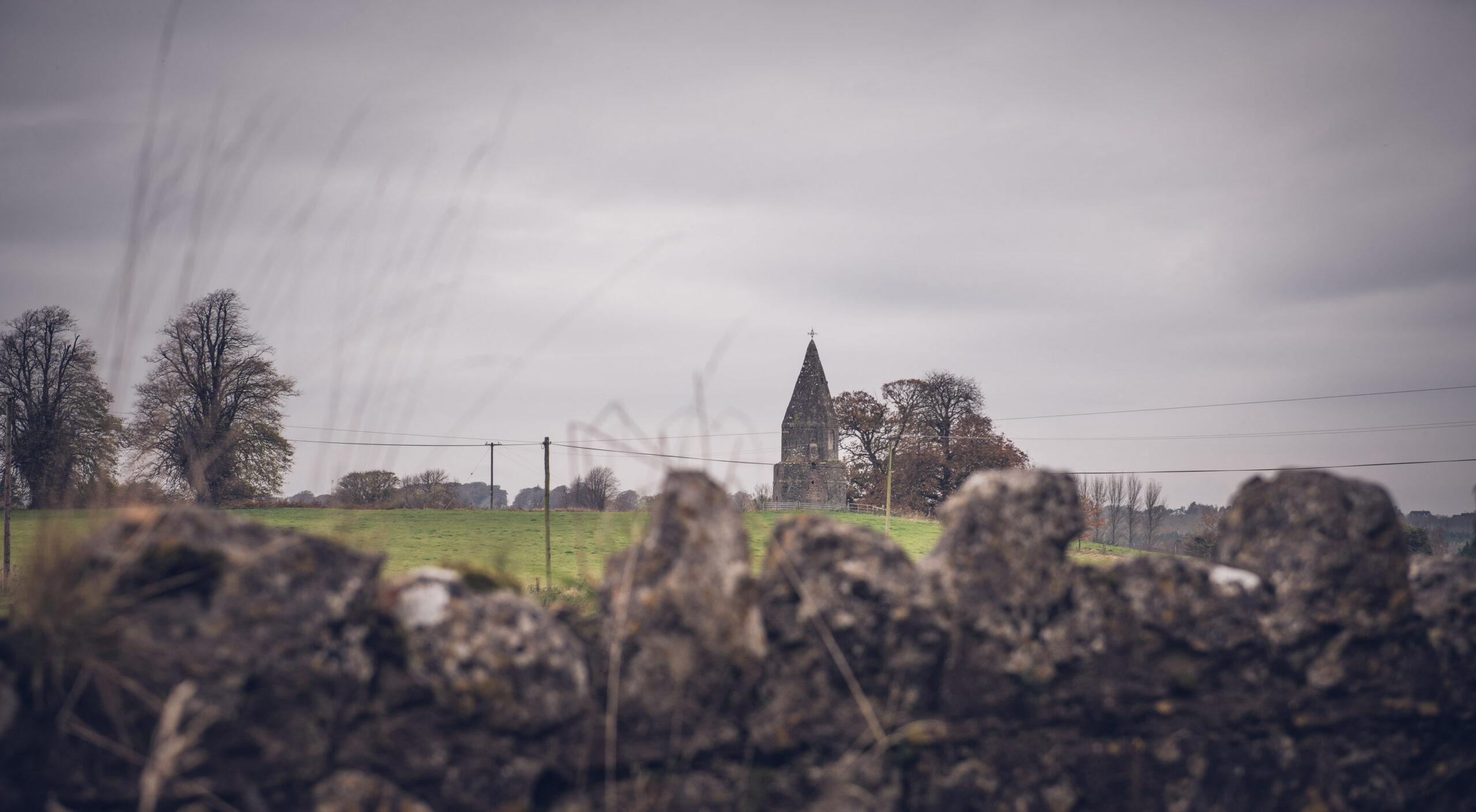
The barony of Kilkenny West is divided into four civil parishes: Bunown, Drumraney, Kilkenny West, and Noughaval, each centred on an early medieval church site. The present-day Catholic parish of Tubberclair is a union of the parishes of Bunown and Kilkenny West, along with the addition of seven townlands from Noughaval parish. The remainder of Noughaval parish is better known as Tang, a Catholic half-parish. The ancient parish churches of Kilkenny West and Bunown are both shown as roofless ruins on the 1808 Grand Jury Map of Co. Westmeath. It appears a new chapel was built shortly afterwards in the townland of Toberclare, as in 1813 Bishop Plunkett conducted his visitation (for confirmation) at ‘Tubber-Clare’. The parish continued to be known as Kilkenny West and Bunown (in various forms), and sometimes as ‘The Glasson Parish’, throughout the nineteenth century, but the name Tubberclair (this is the most common spelling of the name today), gradually became synonymous with the parish. In 1823, the parish priest, Fr McCormack, was living in nearby Carrickfinn, and Carrickfinn boreen is still today known as ‘The Priest’s Boreen’. His successor, Fr Kearney, lived at Shannon View, in the townland of Toberclare. This house was described in 1837 as a ‘gentleman’s seat’, which it seems, Fr Kearney renamed Ardclair. Fr Murray built a new presbytery at its current location in the 1880s, which was replaced in 1988.
The Church of Ireland administered Kilkenny West and Bunown as separate parishes until the 1870s. The original medieval parish church of Bunown is on an elevated site close to the lakeshore in the townland of Bunown, near Glasson. The Church of Ireland built a new church for Bunown parish (also spelt Benown) at a site in Portlick in 1818, 3km north of the old church. A new church was also built at Kilkenny West, on the site of the medieval church in 1839. There was also a chapel of ease on the street of Glasson (c.1860-1929). Kilkenny West church was dismantled c.1965, and Benown Church (Portlick) is now the sole Church of Ireland parish church.
The population of Tubberclair in 2022 was 2362, but given the rapid growth of recent years the population in 2024 may now be 2500 or more. The earliest population figures we have for the parish are from the 1831 census. Only part of the data has survived, but a population of c.5300 can be extrapolated from the available information. More definite information is available from 1841 on:
| YEAR | POPULATION |
| 1841 | 5419 |
| 1851 | 4083 |
| 1861 | 3569 |
| 1871 | 3137 |
| 1881 | 2885 |
| 1891 | 2507 |
| 1901 | 2218 |
| 1911 | 2089 |
| 1926 | 1738 |
| 1936 | 1617 |
| 1946 | 1423 |
| 1951 | 1364 |
| 1956 | 1285 |
| 1961 | 1301 |
| 1966 | 1294 |
| 1971 | 1233 |
| 1979 | 1316 |
| 1981 | 1396 |
| 1986 | 1563 |
| 1991 | 1645 |
| 1996 | 1708 |
| 2002 | 1845 |
| 2006 | 1970 |
| 2011 | 2090 |
| 2016 | 2156 |
| 2022 | 2362 |

In 1841 the parish had a population of 5419, almost certainly its highest ever level. The failure of the potato crop in successive years from 1845 until the early 1850s, coupled with widespread outbreaks of disease and consequent emigration had a devastating effect on the population. As the population would have continued to grow until 1845, the 1851 total represents a drop of c.27%. Conditions varied significantly from townland to townland during the famine years, as did the attitude of the landlords. Famine relief works saw many new roads built, such as the road through Liss Bog, the road from Glasson to Brittas, and the ‘New Line’ from Kilfaughney to Cartroncroy. Some townlands like Glassan, Muckanagh, Kilkenny Abbey, Lissakillen North, Killinure North, Lissatunny, and Waterstown saw increases in population between 1841 and 1851. The populations on the islands on Lough Ree (Inchmore, Hare Island, Inchbofin, Inchturk, and Nuns Island) remained, for the most part, fairly stable. Townlands which saw significant decreases include: Brittas, Lissakillen South, Lissoy, Littetown, Kilkenny West and Ballaghkeeran Big. The townlands of Portlick and Whinning, owned by the Smyth family of Portlick Castle, seem to have been almost entirely cleared. The population reduced by 85% in both cases, with a drop from 46 houses to 6, and 19 houses to 2 respectively. The townland of Whinning was entirely uninhabited by 1861 and remains so to this day.
The population continued to decline after the famine until 1956. A modest increase was recorded in 1961. It remained relatively stable in the 1960s but has grown continuously since 1971, and has actually doubled in the last 50 years. Despite this, the 2022 population is just 43.5% of the pre-famine total of 5419.
Prior to the mid-twentieth century mixed-farming was the mainstay of the local economy. Other primary sector activities in the parish included cutting and rearing turf for sale, eel-fishing and draft-net fishing for trout and perch on Lough Ree, small-scale sand and gravel extraction and quarrying, and, around the time of the second World War, the cutting and supply of trees from local woods and old estates to local sawmills. These activities were supported by a variety of trades and craft workers, such as carpenters, blacksmiths, wheelwrights, boat-builders, stonemasons, thatchers, cobblers, tailors, butchers etc. There were a very small number of public sector jobs (dispensary nurse & doctor, Garda, national teacher, post office etc.), as well as those in commercial employment or self-employed (local shops, pubs, garages, livestock dealers, millers etc.), and other occupations such as the priest and other religious.  Some small farmers would have supplemented their income by taking seasonal work on the roads. From the early 1960s the advent of State forestry schemes also supplied some employment. Tourism was, for the most part, limited to a small number of visiting  anglers and returned emigrants on holidays.
Industrial employment in Athlone was expanded in the 1930s with government assistance, followed by a period of relative stagnation in the 1940s and 50s. An important innovation at this time was rural electrification – the grid was extended throughout the parish between March 1952 and October 1957. Public housing schemes in Kilkenny West and Liss (early 1950s), and Glasson (c.1970) as well as the provision of individual council houses and county council loans stimulated some economic activity and improved housing conditions locally. The increased availability of motor transport in the 1960s allowed people to travel further away from home for work and the public sector also began to expand into new areas. More rapid employment growth took place from the early 1970s with the advent of foreign investment and the development of large-scale manufacturing, pharmaceutical and other industries in the Athlone area.
Farming also changed significantly at this time. Some farmers in the parish began to specialising in dairying with the opening of the Creamery in Moate in 1958. As off-farm employment became more available, some left farming allowing others to consolidate their holdings. Tillage, vegetable, pig, poultry and egg production all declined as beef and sheep production increased, with changes often determined by the EU subsidy regime and global commodity markets, rather than local food consumption. Some new forms of agriculture such as mushroom production emerged in the late 1980s. There was also an increase in horse-breeding from this time, for show-jumping, hunting, and racing.
There was a significant expansion in house-building and construction of all kinds from the 1970s, which allowed some local industries such as precast concrete manufacture and later readimix concrete production in Glasson to develop. Other local industries such as corn-milling and many local crafts began to disappear at this time. Some, like boat-building, have continued, albeit at a small-scale. Eel-fishing was banned in 2010. Commercial draft-netting for trout is still practised, but is seasonal and the number of annual licenses is limited to a maximum of 12 for the whole of Lough Ree by law.
The most significant development of the local economy has been the expansion of tourism from the late 1960s. Initially, this was focussed on the area’s most attractive natural feature, Lough Ree. There was a general increase in boating tourism in Ireland following the founding of the Inland Waterways Association of Ireland (1954) and the new availability of affordable outboard engines (late 1950s), followed by cruiser-hire from the 1960s. New marinas were built at Portaneena (1958), Ballykeeran (1976), and Killinure (early 1980s). Cruiser-hire was a key part of these businesses and with increased visitor numbers in the area overall new services were required. Chalets were built in Killinure to accommodate visiting fishermen in the 1960s and Ballykeeran Caravan Park opened c.1973. A new pub located near the lakeshore opened in Killenmore in 1985. Killenmore is the site of the annual fishing competitions of the Ballykeeran and Killenmore Anglers club which attracts large numbers of visitors every year, and is an important public access point for boats on Lough Ree as well as for moving livestock to and from the islands on Lough Ree.
A small hotel was added to the SGS marina in Ballykeeran in 1987. The Portlick and Whinning amenity area came into public ownership in the late 1970s/early 1980s and was subsequently opened to the public – lakeside self-catering accommodation opened at nearby Carnakilla Point in 1988 and was subsequently expanded. A number of B&Bs also opened in the 1980s.
As the provision of tourist accommodation developed the focus shifted somewhat from the lake to hospitality. The Village Restaurant opened in 1986, following the renovation of the old Garda Barracks in Glasson, an attractive and historic building. A craft shop, later providing tea and coffee, opened in Glasson in 1991. Neighbouring Grogan’s pub began to serve food in the early 1990s and the Wineport restaurant opened in Portaneena in 1992 and has since been extended a number of times to include hotel accommodation. One of the most significant developments was the opening of Glasson Golf Course (Killinure) in 1993 which broadened the local tourist offering as well as attracting visitors year-round. A hotel was opened at the Golf Course in 1998, which has been extended and rebranded in recent years, and is an important venue for weddings and other functions. Portlick Castle was renovated and opened as a wedding venue around this time.
Smaller marinas were developed in Ballinlough and Muckanagh in the 2000s, while the public landing-place at Muckanagh was improved at this time. The Killinure area in particular became popular with German tourists and a public restaurant was opened there in 2004. This was followed in 2005 by Farrell’s The Village Inn in Glasson, which expanded into the food business in that year (now trading as The Villager).

Villages
There are three villages in the parish. Glasson, the largest centre (pop. 218, in 2022), has been a settlement of some kind since at least the early seventeenth century, when it was the location of an important  corn mill. A second mill was built sometime in the eighteenth century. One of the mills was later also used for textile processing. From the 1780s, the current street began to develop,  followed in the early nineteenth century by a succession of important additional functions such as a police station, dispensary, court house and post office, in addition to the two public houses/shops and other businesses. A school was built in 1844, and a Church of Ireland chapel around 1860. The two pubs, Grogan’s (formerly Ms Murphy’s) and The Villager (formerly Farrell’s The Village Inn) have long been mainstays of commercial and social life in the village – they both originally provided groceries as well as trading in other merchanise, such as animal feeds and agricultural implements. Tom Fagan’s Central Stores was an important fixture in the village for many years, supplying fuel, groceries and light hardware. Spollens opened a second service station in 1977, now a Centra. The village continues to be the centre of many services for the parish, with a community centre, doctor’s surgery, pharmacy, service station and shop, and two beauty clinics, among other businesses.
Ballykeeran also first developed as a centre of milling, as well as being an important crossing point of the Breensford River, which separated the barony of Kilkenny West from the territory of the Ó Braoin family of Brawny. Following the rebellion of Irish Catholics in 1641 the pass at Ballykeeran was closed by Irish forces as part of the blockade of Athlone in 1641/2. A cluster of buildings is shown on mid-seventeenth century maps around the site of the present village. By 1837 there were two mills in operation there. One of these was quite substantial. Owned by Conor Duffy, it continued to operate until the 1970s, or perhaps later. Most of the mill buildings were demolished in the mid-1990s. Ballykeeran has one pub and up to the 1990s had its own post office, and a shop: ‘Riverside Stores’.
Tubberclair is what is described as a ‘chapel-village’ – small settlements which built up around a newly built Catholic churches from the early nineteenth century. Typically they include, today, a church, a national school, and, frequently, a GAA pitch. Tubberclair, though very spread out, has all three, as well a community hall. It also had a small shop, located directly opposite the church, which was very popular after Sunday mass (Spollen’s - closed in the early 2000s). A service station was opened on the the N55 to the north of the village in the 1960s ‘Goldsmith Stores’, but closed in recent years. A garage and later a shop and filling station also operated at Lackan, just to the north of Tubberclair.

Leisure & social life and and education:

Historically there were four national schools in the parish (Ballynacliffey, Inchmore, Glasson and Tubberclair), but these were amalgamated in the course of the the 20th century with Tubberclair National School. The school has c. 300 pupils enrolled at present and is the focal point of the community.

Notes:
GAA Club
LGFC
Point-to-point/Hunt from 1888?

Hurling – 1880s

Glasson Carnival (> 1983?) & other festivals – Rose of Glasson etc.

Liss club 1927?

Gun Club 1960s

Killinure Pipe and Drum Band

Tubberclair Pipe Band

Killenmore Anglers

Boxing Club – 1960s
What are the boundaries of Tubberclair?
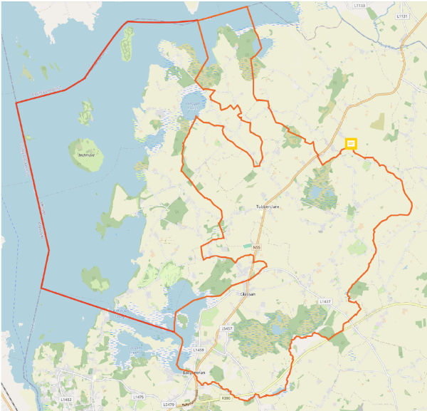
Tubberclair Parish = all the area within the red lines (the red line which runs through the centre of the parish is the old boundary of Kilkenny West Civil Parish).
See the map above for the parish boundaries. For reference, the parish is bound to the west by Lough Ree, and to the south and east by the Breensford River (crossed by the N55 at Ballykeeran), and its tributaries, such as the Rath River. The northern boundary of the parish is less defined by natural features, it crosses the N55 at Lissoy (at the southern end of the widened section of the N55, approx 1km south of The Three Jolly Pigeons).